
The Society holds a huge number of resources that can assist researchers with their own projects.
Our resources include:
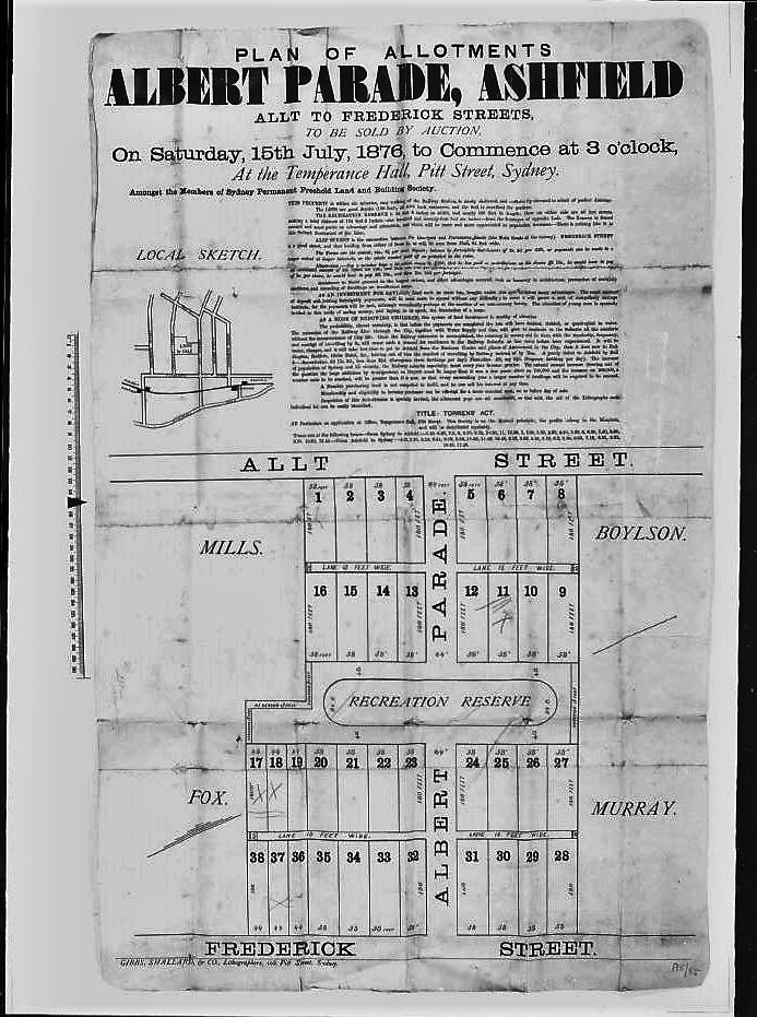
Subdivision Plans
A collection of over 800 local subdivision plans, all those held by Mitchell Library (microfiche). These are particularly useful in determining when a block of land was subdivided.
We have digital copies of the subdivision plans for Ashfield, Ashbury, Haberfield, Hurlstone, Dulwich Hill Park and Summer Hill.
The plans have been catalogued under the areas Ashfield, Summer Hill, Haberfield and Miscellaneous (pencil plans), and then according to the name of the subdivision, where known. Where we have a plan of an unnamed subdivision, it will usually be listed under Ashfield, or the particular suburb, when this has been identified on the plan.
These plans, not all of which are dated, show the subdivision of various parcels of land for closer settlement, usually house allotments.
Many subdivisions were offered for sale several times, especially during periods of economic depression. Where a plan shows a sale held on a particular day of a particular month, but no year is given, the precise year can be determined by consulting the ‘universal calendar’.
Water Board Plans
The Society holds copies of Water Board plans of the (former) Ashfield Municipality as it was in 1890-93 (Aperture cards and hard copies)
These plans are invaluable as they show the outline or footprint of buildings on the allotments that then existed.
The aperture cards do not include much of the subdivision for Haberfield but elsewhere show every street, together with the outline of every building, fence line, gates, wells. etc. The plans do not indicate whether a building is one or more storeys in height, but they do show whether the structure is built of stone, wood. brick or iron. The location of all verandahs is shown, and often front steps and paths. Most plans also show whether the front fence had a masonry footing. Names of houses are often given, but some areas surveyed have few names.
The shading of any structure on a plan indicates that it was erected at some time between the first survey, usually carried out in 1889 or 1890, and a revised survey carried out c. 1893. The relevant dates of both surveys should be shown on each fiche. If not evident, try looking on the plan of an adjacent area prepared by the same surveyor.
In some parts of the district, later overlays or additions have been made to the early surveys, even up to the 1940s.
The Society also holds hard copies of plans of the (former) Ashfield Municipality representing further surveys carried out by the Water Board in the 1920s and 30s. Some of these plans are dated, while others are undated or the date has been obscured. They are drawn to scale, but appear to be reproductions of field books, so the additions shown on them are probably cumulative rather than dating from any particular survey. These plans are invaluable for showing additions that may have been made since 1893 and in picking up all buildings erected between that date and the date of the survey carried out in the inter-war years. They do not indicate the type of building material used, but they do show the location of verandahs.
Ashfield Council Rate Books, 1872-1890 (microfilm)
The Society holds copies of the Rate Books of Ashfield Council for North Ward from 1872 to 1890, for South Ward from 1872 to 1885, and for East Ward from its inception in 1880 until 1890. These Books give a very accurate picture of when a house or other building was actually erected. They usually provide the name of both owner and occupier, and they may (depending on the year) give some details of the building itself, such as the number of storeys, the number of rooms, whether built of brick, stone or timber, and the material used on the roof. The valuation figure given in the rate books, used in conjunction with the Water Board plan footprint, can often indicate whether a building was of two storeys. Rate books are usually arranged by street, but in 1882 the entries are listed by owner, more or less arranged in alphabetical order. We have prepared a year by year index to this microfilm, which has been cut into sizes to fit the microfiche reader.
Ashfield Council Minutes 1872-1920 (microfilm)
Ashfield Council Valuation Books, 1908-10, 1920, 1922-26 (microfiche)
Ashfield Council Building Applications 1909-1980 (microfiche)
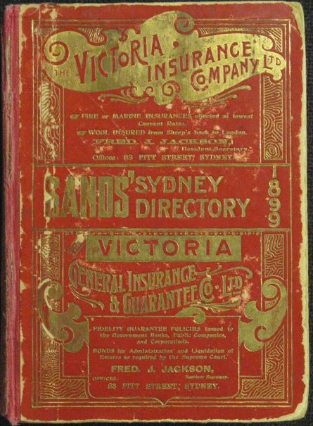
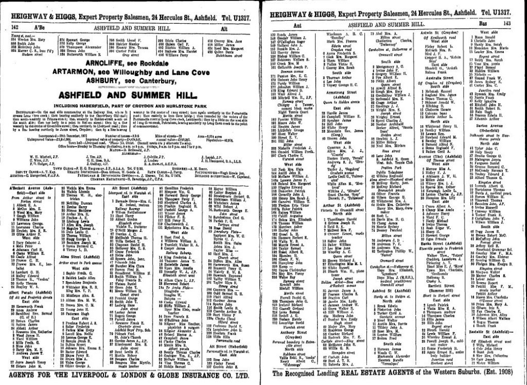
Sands‘ Sydney Directories (microfiche)
Sands Directories were published by the John Sands stationery firm from 1858 until 1933 and appeared every year, except 1860, 1862, 1872, 1878 and 1881.
The City of Sydney, Archives and History Resources (https://archives.cityofsydney.nsw.gov.au/nodes/view/495003) has digital copies of the Sands Postal Directories. These digital copies are searchable!
These directories will provide:
- the names of people who lived in the house.
- the occupations of residents (sometimes!).
- the economic uses of the building – for example, a house/apartment may be attached to a shop or a factory.
- previous structures on the site.
- house name (if any depicted).
- approximate construction date.
- changes in street numbering.
The Society holds the complete Sands on microfiche. We also hold hard copies of the Ashfield Municipal Area listings for a number of the years.
Sands is invaluable for locating persons, identifying house names. and checking trades, professions, etc. A more accurate picture is usually gained by consulting entries over a period of years, as not every year’s edition picks up every householder. Presumably, Sands had agents who visited each property in Sydney annually (we believe in about August) and some omissions may be the result of occupiers not being home when the agent called, or properties being unoccupied.
Note that the entries in these directories represent occupiers, not owners. The names of the latter must be found from information on the title deeds held in the New South Wales Land Titles Office, or from Council Rate Books.
The spelling of some names is occasionally wrong. Often a check in a nearby year will reveal that a misspelling has been corrected. Note also that house numbers in most streets changed, often quite dramatically. Most changes appear to have taken place in Ashfield Municipality in 1916 or in nearby years.
The two chief lists in each edition of Sands are the municipal directory and the alphabetical directory. Remember that many old municipalities, such as Five Dock, Petersham and Enfield, are no longer in existence. Prior to 1884, the Ashfield Municipal List was arranged alphabetically rather than by individual streets. When searching through these early years it is sometimes difficult to pinpoint precisely where certain people lived. Always cross-check the municipal directory with the alphabetical directory. Sometimes this will reveal information not contained in the municipal list. If the person you are seeking had a trade or profession, or was involved in the church, military or public service, he/she may be listed in the appropriate special section of the directory.
House names were often changed frequently, and tenants as well as owners tended to change the name of a house when they moved in. 1917 is the last year in which house names were widely given for Ashfield in this directory.
Allow one year for Sands to pick up a new occupier ie: if a person is listed in the 1915 edition for the first time, it is likely that he/she took up residence during 1914.
If used in conjunction with information derived from title deeds and Council ratebooks. Sands Directories can usually be relied upon to provide the answers to many preliminary enquiries about people and places in the (former) Ashfield Municipality.
Other useful sources of early house names are the Ashfield Council Valuation Books and some house names are listed on the H E C Robinson c. 1910 ward maps of Ashfield Municipality, copies of which we hold.
Wise’s Post Office Directory of Ashfield 1936 (hard copy)
The NSW Post Office (and Commercial) Directories, which are often referred to as Wise’s Directories started in the mid-1880s and continued until 1950, covering more than a decade after Sands stopped publishing. We have a hard copy of the 1936 Directory of Ashfield.
There are two separate listings. The alphabetical listing shows the occupier, the address and sometimes the occupation of the householder. An asterisk (*) marks all of the entries where the occupier is also the owner of the property. In the street directory, Wise’s lists the name of every householder in a street and very often shows the house names. In the case of commercial premises or households that have a ‘home business’, the directory most often shows the occupation eg. grocer, chemist, herbalist.
NSW Post Office Directory for 1904 (CD-Rom)
This CD-ROM is a searchable CD produced by Archive CD Books Australia Pty Ltd. To use this resource, first insert the CD-ROM into the computer and it will automatically bring up the program. Click on ‘Contents’ and select which directory you wish to search. There is a wealth of information contained on this CD-ROM for the researcher. In the Trades Directory there are many advertisements for companies and individual businesses.
The NSW Telephone Exchange List of Subscribers for 1913 (CD-Rom)
The original telephone directory was issued in May 1913 and lists over 30,000 names of subscribers in Sydney and country NSW in over 600 pages. Occupations of subscribers are often given together with the address and the exchange. The preliminary pages include other information giving insight into communications and society more than 100 years ago.
The Advertiser, 1888-1909, Ashfield newspaper (microfilm).
This newspaper circulated in Ashfield, Summer Hill, Croydon, Canterbury, Burwood, Concord, Enfield, Strathfield, Dobroyde, Five Dock, Petersham, Leichhardt, Dulwich Hill and Marrickville.
The Society holds the complete available collection of this local newspaper. It was published by George Watson from his premises in Liverpool Road. Issues after 1909, when Watson sold the paper, unfortunately do not survive. The years 1891-1907 are also available on film that has been cut to fiche size for use in the microfiche reader.
This newspaper holds a massive amount of information, and Watson appears to have been a reliable journalist. It is not only the news sections that are valuable, but also the advertisements. which often provide useful information about commercial traders and their premises.
The Ashfield Argus, 1924-1960 (incomplete, microfilm)
The Society holds copies of all surviving issues of The Argus, founded by A A James. and published from 1924 until the 1960s. Two reels of film are available, covering the period 1924-1942, in which there are many missing editions, and 1958-1963, which is a more complete set. Researchers wishing to consult a hard copy for the purposes of reproducing a photograph or advertisement may be able to do so by negotiation with a Rooms’ research officer.
Newspaper Cuttings (1960s-1990s)
Miscellaneous cuttings relating to Ashfield and district.
NSW Register of Births, Deaths & Marriages (CD-Rom)
If you’re looking to trace your family history in New South Wales, the Registry’s records are the best place to start.
These are published by Royal Melbourne Institute of Technology in association with the Registry of Births. Deaths and Marriages, New South Wales . The Society holds three CD-Roms for Births, Deaths and Marriages:
- PIONEERS SERIES 1788 – 1888
- FEDERATION SERIES 1889 – 1918 (births are only listed up until 1915)
- BETWEEN THE WARS SERIES 1919- 1945 (deaths and marriages only) and
- Handbook – Getting Started
Internet access is available to several years’ records beyond the limits of the CD-Roms.
Both the Federation Series and the Pioneers Series CD-Roms provide access to the indexes in three databases: Births, Deaths and Marriages. Each database must be searched separately -it is not possible to search births, deaths and marriages at the same time.
Soc. of Australian Genealogists Cemetery Transcriptions for Rookwood, Macquarie Park, Waverley & South Head (CD- Rom)
Gravestone Inscriptions (Hard Copies)
- St John’s Cemetery, Ashfield
- St David’s Ramsay Family Cemetery
- St Paul’s Cemetery, Canterbury (many Ashfield residents are buried here)
1901 Commonwealth Census (Microfiche)
Listing is by street address (old numbers are used), and the entry gives the head of the household, the number of persons present, whether male or female, and the number of Chinese and Aborigines. Some house names are also listed.
1903 Commonwealth Electoral Roll (Hard Copy)
This is the first Commonwealth roll, and covers Ashfield, Summer Hill, Dobroyde and Croydon. Females are included on an electoral roll for the first time. Listed alphabetically, the Roll gives name, occupation and address. Note that street numbers given in this Roll are different from those of today.
Electoral Roll for the Seat of Evans 1954 (Hard Copy)
This is a bound copy of the 1954 electoral roll for the seat of Evans (which included the Municipality of Ashfield and surrounding suburbs). The Roll gives alphabetical listings of residents and their addresses.
Ashfield Council Minutes (Microfiche)
The Society holds copies of the Minutes of Ashfield Council from its first meeting in 1872 up until the end of 1922. Early minutes contain little detail about individual buildings, but some useful information can be gleaned from correspondence reports and from such things as local government election results and early name changes of various streets. (Many of these are also listed in the 1993 Ashfield Heritage Study).
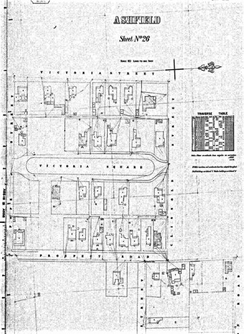
Miscellaneous Maps and Plans
The Society holds hard copies of scores of maps and plans, dating from c. 1840 to the twentieth century. These have not yet been catalogued. but our research officers may be able to help. Some maps and plans of particular interest are:
- John Armstrong’s 1841 map of the Village of South Ashfield
- Edward Knapp’s 1854 map of part of the Ashfield Park Estate
- An 1859 map showing a subdivision of Ashfield Park Estate
- All c.1865 Deposited Plan maps of the Canterbury Estate (most of south Ashfield and south Summer Hill)
- Mr Surveyor Hedgeland’s c.1874 map of Liverpool Road
- Higginbotham & Robinson’s 1883 and 1886 Maps of the Municipality of Ashfield
- Robinson’s c.1910 maps of the four Wards of Ashfield Council (these include many house names)
- Parish Maps: Petersham and Concord (these show the precise boundaries of the original land grants)
- Ashfield Council’s 1975 and 1985 planning maps (these show most Deposited Plan numbers, which can then be accessed in the Land Titles Office)
Ashfield Council Valuation Books (Microfiche)
We hold copies of Ashfield Council Valuation Books on fiche for the years 1908-10, 1920, 1922-26.
Photographs
The Society has a collection of thousands of photographs. Most of these date from the early 1970s to the present day, but our collection of earlier photographs is continually being enlarged with donations from members and the general public. The collection has been grouped into subject headings such as
- churches
- schools
- commerce and industry
- cemeteries
- district dwellings etc.
There are also groupings of particular series or origins of photographs such as
- The Wolfers Collection.
- Quong Tart.
- Yesterday’s Images.
- Tyrrell Collection.
Every photograph has been uniquely numbered and placed in a grouping most suitable for its subject or origin.
Despite the collection containing over five thousand photographs, please do not expect to find an historic picture of your house in our collection -if we do have one, consider yourself very, very lucky!! Most of our early photographs tend to be of mansions or major public buildings. rather than more modest dwellings.
The photograph collection is computer indexed. A hard copy of the index is also available for inspection.
We hold copies of all photographs relevant to the (former) Ashfield Municipality that we have been able to locate at the Mitchell Library, the Historic Houses Trust, the National Trust and in the Tyrrell Collection. We also hold copies of the Wolfers Collection, being 108 images of Haberfield and Ashfield houses from the 1920s.
Please note that we cannot sell copies of those photographs in our collection that we have obtained from other institutions – w e can tell you where we obtained them, but you must negotiate purchase personally with the institution concerned. We do. however, sell copies of photographs for which we hold the copyright. Prices are available on request. We do not lend any photograph in our collection to others for copying.
Heritage Studies and Conservation Plans
Of particular local value are the following:
- Ashfield Heritage Study (1993),
- Vol 1: general history; proposed conservation areas; architectural and landscape essays; origins of street names
- Vol 2: separate inventory sheets for 300 existing and proposed heritage items
- Haberfield Main Street Study (1994)
- Haberfield Heritage Study (c.1987)
- Summer Hill Post Office Conservation Plan
- Ashfield Police Station Conservation Plan
- Thirning Villa draft Conservation Plan
Other Information on Ashfield and District
We hold a great deal of other printed material relating specifically to Ashfield, Summer Hill, Haberfield and Croydon. Included are the following general texts and more specific publications:
- Speed the Plough (Ashfield’s Official Bicentennial History) Ashfield, 1872-1972 (published by Ashfield Council)
- Between Two Highways (the history of Croydon)
- Trinity – the daring of your name (history of Trinity Grammar)
- The Golden Hope (history of PLC, Croydon)
- Clouds of dust, buckets of blood (history of Western Suburbs Rugby League Football Club)
- Twinings (history of St Vincent’s Church)
- Lock, Stock and Barrell, (the Underwoods)
- ‘Old Ashfield’ – a series of articles in The Advertiser in 1897-98
Institutions and Places
- Pittwood Home
- Milleewa Boys Home (Annual Reports 1919-41; * transcripts of interviews with Old Boys)
- The Cinemas of Ashfield
- Lodge Haberfield
- The Infants’ Home
- Western Suburbs Rugby League Football Club
- Yasmar, Haberfield
- Glentworth; Ashfield
- Wyanarie, Ashfield
- Lily Cottage, Summer Hill (Thos Dean’s house)
- Kelvin Grove, Summer Hill
- Kyamba, Summer Hill
- Urangara (formerly Wynellai), Summer Hill
- Essendene. Ashfield
- lngleburn, Summer Hill (20 Rosemount Ave)
- Taringa, Ashfield
- Dobroyde House, Haberfield
- Ambleside (Ashfield Castle), Ashfield
- Chesterfield, Summer Hill
- Hillcrest, Summer Hill
- Eltham, Summer Hill
- Ormiston, Summer Hill
- Fernlea, Ashfield
- Coniston, Ashfield
- Walthamstow, Ashfield
- Amesbury, Ashfield
- Mountjoy, Ashfield
- Hilldropt Kellros, Summer Hill
- Ashfield Masonic Hospital
- Post Office histories, Ashfield, Summer Hill, Croydon and Haberfield
- The railway, Ashfield
- Ashfield Evening College
- Plumbers’ Supplies Co-operative Ltd
- St Basil’s Homes
- Waddell’s Garage, Liverpool Road
- The Glassop case, 1907
- Ashfield Racecourse
- YWCA
- Old Sheep Quarantine Ground
- Wilshire’s Paddock Freshwater Estate
- Victoria Square (1876 lots and sales)
- James Underwood estate
- Plynlimmon estate
- Murrel’s estate
- Richardson’s estate
- Commonwealth Bank, Summer Hill
Schools
We have information on the following schools:
- Summer Hill Public School
- Normanhurst School Ashfield (including photos)
- PLC Croydon
- Trinity Grammar School Summer Hill
- Dobroyde School, 1862-76
- Bethlehem College Ashfield
- De La Salle College Ashfield (Elmswood)
- Ashfield Public School
- Ashfield Boys College/Grammar School
- a number of small private schools
Churches
We have histories of the following churches:
- Ashfield Presbyterian Church (1936 and 1976)
- Ashfield Methodist (now Uniting) Church (1936)
- St John’s Church of England Ashfield (1940 and 1991)
- St Andrew’s Church of England, Summer Hill (1981 )
- St Vincent’s Catholic Church Ashfield (1944 and 1994)
- St David’s, Haberfield (1968 and 1969)
- St Oswald’s, Haberfield (1977)
- Holy Innocents, Croydon (1974)
- St Paul’s, Canterbury (1960)
- St Christophorus (formerly Croydon Congregational) (1973)
- St James, Croydon
- St Patrick’s Catholic Church, Summer Hill
Family Histories
While the dividing line between local history and family history is usually blurred, we have grouped a number of papers relating to specific individuals or families in one section. We have books or detailed family history notes on the following:
- The Elphinstones
- The Underwoods
- The Reuss family
- The Hallorans
- The Lumsdaines
- John Harris (First Fleet emancipist)
- Thomas and Finetta Brown
- The Hodgson-Miles families
- Mark Hammond
- H E Pratten
- W G Hilliard
- Quong Tart
- Henry Hinder
- Mead family
- Chas D Websdale
- Lucy Ann Owen (see under Dobroyde School)
- John William Buckley
- James Cunningham
- Clunies-Ross family